


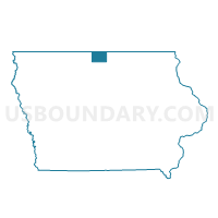
SCARVILLE Voting District, Winnebago County, Iowa
About
Outline

Summary
| Unique Area Identifier | 583732 |
| Name | SCARVILLE Voting District |
| County | Winnebago County |
| State | Iowa |
| Area (square miles) | 0.08 |
| Land Area (square miles) | 0.08 |
| Water Area (square miles) | 0.00 |
| % of Land Area | 100.00 |
| % of Water Area | 0.00 |
| Latitude of the Internal Point | 43.47096690 |
| Longtitude of the Internal Point | -93.61657180 |
Maps

Graphs
Select a template below for downloading or customizing gragh for SCARVILLE Voting District, Winnebago County, Iowa


Neighbors
Neighoring Voting District (by Name) Neighboring Voting District on the Map
- LOGAN TWP W/O SCARVILLE Voting District, Winnebago County, IA
- NORWAY TWP W/O SCARVILLE Voting District, Winnebago County, IA